Projects
These are some of KurrawongAI's recent projects:

OGC's Reference Data Platform
KurrawongAI has developed Prez, our flagship Semantic Web / Knowledge Graph API over multiple years and deployed it for many organisations. We have recently upgraded the Open Geospatial Consortium's RAINBOW reference data platform to use Prez which allows it to deliver human- and machine-readable forms of a wide array of definitional items, such as the OGC,s 1,500 international spatial data standards, fundamental spatial data function units known as Building Blocks, vocabularies of controlled terms - from the OGC and those from other standard organisations that they publish - and soon, in late 2025, persistent reference scientific data workflows, ontologies and other complex data models.
KurrawongAI's deep knowledge of spatial data on the web - we contribute to international standards, such as GeoSPARQL means we can specialise our generic Knowledge Graph tools for complex spatial data use effectively.

Resources domain integrated AI
In 2024 - 2025, we developed and deployed an instance of KaiFrame, our AI tool bundle product, for a large international mining company.
We used KaiFrame's data marshalling and processing workflows to process thousands of datasets of mixed files, many of which contained spatial data files from which we automatically extracted extent information. We also processed close to 1/2 million domain documents, using AI tools to extract text for chat UIs and images for specialised processing.
As we always do, we implemented a Knowledge Graph for this deployment and this one contains specialised information about the company's target resources as well as general reference geological information which we know very well from our extensive national and international geological work, for example with the Commission for Geoscience Information who's standardised vocabularies of controlled terms we've provided technical publication tools for, for many years.
We then created both a stand-alone catalogue UI to KaiFrame's content, to allow for data management, and a chat search and data loading UI embedded within ESRI's ArcGIS Online which the company's staff use every day.
We know this project has been a success because our work with the mining company continues.

Indigenous Data Network Catalogue Project
Over several years we've designed a profile of DCAT, the well-known data cataloguing model for the better representation of Indigenous data governance concerns and implemented a series of reference data catalogues for the Indigenous Studies Unit at the University of Melbourne to support a national Indigenous Data Network.
This work is groundbreaking in several ways:
- implementation of a scores calculator that can automatically generate FAIR and CARE scores for catalogued data
- provision of catalogues of reference data that assist government, NGOs and any other holder of Indigenous data to better characterise it in metadata
- Indigenous spatial reference datasets in Semantic Web form, such as the Agreements, Treaties and Negotiated Settlements (ATNS) database
- a new Semantic Web spatial data models for the representation of fuzzy geometries
- a Keeping Place for at-risk Indigenous data
- methods for the discovery of Indigenous data in large data holdings
Most importantly, this work has provided tools to Indigenous Australians to assist them in taking control of their data.

Vocabulary system establishment for SA's Department for Energy and Mining
This is an example of a common government vocabulary establishment project.
We took Excel spreadsheets of 6 vocabularies of dataset classification terms created by the Department and converted them into SKOS vocabularies.
We also then created 5 other SKOS vocabularies ourselves: several based on external vocabularies, one or two from scratch.
We then created an extension of the VocPub Profile's vocabulary metadata to publish these 11 vocabularies with extended derivation and governance information.
Finally we established a Prez instance, branded for the Department, that published their vocabularies in both human- and machine-readable form for use by their staff, industry and cataloguing systems.
The system is in production online at https://vocabularies.sarig.sa.gov.au/vocab.

Biodiversity Data Repository (BDR)
KurrawongAI developed a robust, scalable and secure national data system for managing species observations for the Department of Climate Change, Energy, the Environment and Water (DCCEEW), comprising millions of records and data sets from across government jurisdictions as well as the private sector. The BDR improves accessibility to Australia's biodiversity data, providing a range of benefits to government, industry and the community including supporting critical environmental functions, improving regulatory processes, and enabling advanced scientific research.
The system is a graph-native database that implements the national graph data model ABIS, which was partially designed by KurrawongAI staff. The software used is GraphDB for data storage and other infrastructure elements, running in an Azure Cloud environment.
This project required a full-service solution for DCCEEW from database technology evaluation, recommendation & test implementations; solutions architecture design; infracode scripting; container management; and custom API creation, through to system hosting services and ongoing system support in line with a Service Level Agreement.
National Address Model
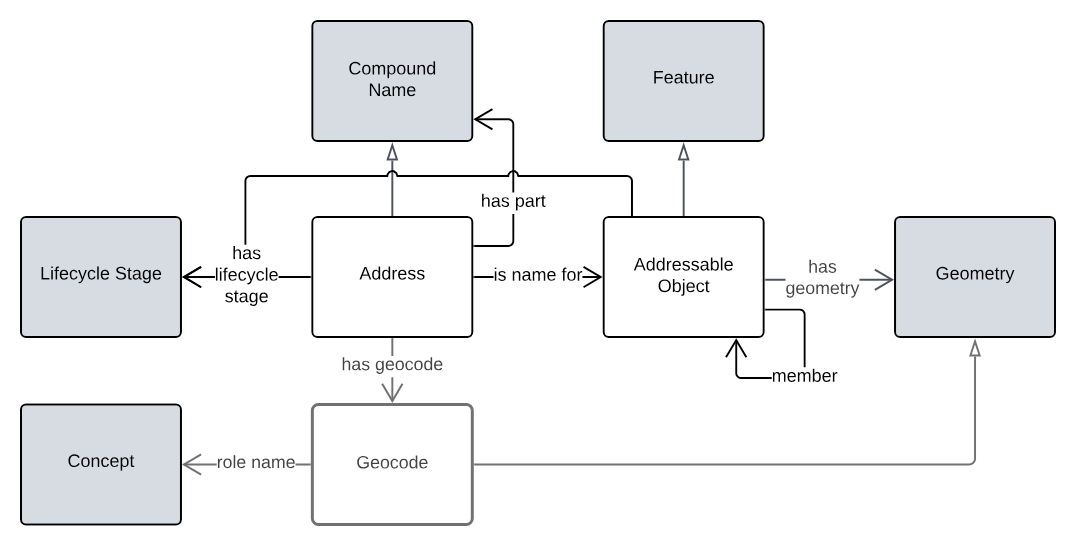
This project developed the ICSM national address model for Australia and New Zealand, in response to the ICSM Address Strategy 2035.
The model is a Semantic Web graph model which has been test implemented in both graph and non-graph (relational) systems.
The model is related to a candidate ICSM Geographical Names model and can be used with the ICSM 3D Cadastral Survey Data Model national standard.
- Address Model
- Queensland Spatial Information Supermodel within which the Address Model fits.
Queensland Spatial Information Datasets Rebuild
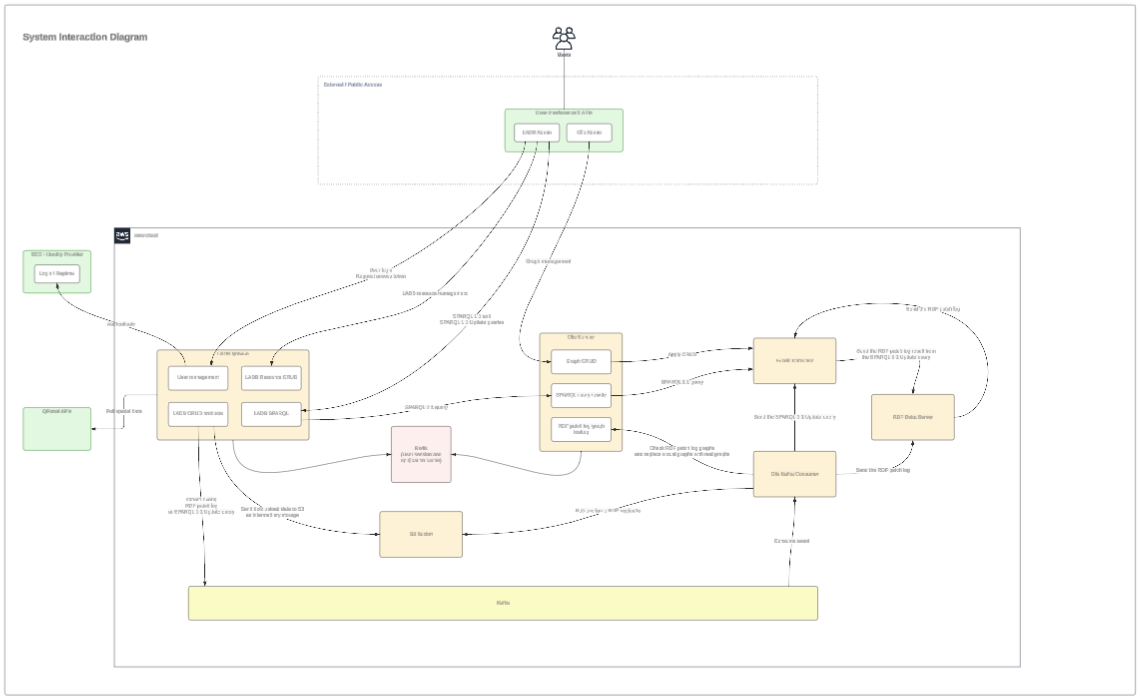
KurrawongAI completed modelling of, then the testing and finally production implementation of Queensland's Address, Road names and Geographical (Place) Names datasets over 3 phases of work. This project not only implemented the first spatial graph-native jurisdictional core datasets in Australia but also established a Spatial Data Exchange Platform which forms the basis of Qld's Department of Natural Resources and Mines, Manufacturing and Regional and Rural Development's spatial data "future state architecture":
- Queensland Spatial Information Supermodel
- overarching framework linking the Address & Place Names models to Cadastral data
- National Address Model
- aligns with ICSM Addressing 2035 strategy, national & international models
- provides graph and relational DB implementations of Qld testing data
- used by the Linked Data version of the G-NAF soon to be online via a Geoscience Australia Foundational Spatial Data Framework initiative
- Candidate National Geographical Names Model
- A profile of the ICSM National Address Model and the Place Names Ontology and candidate for national adoption
